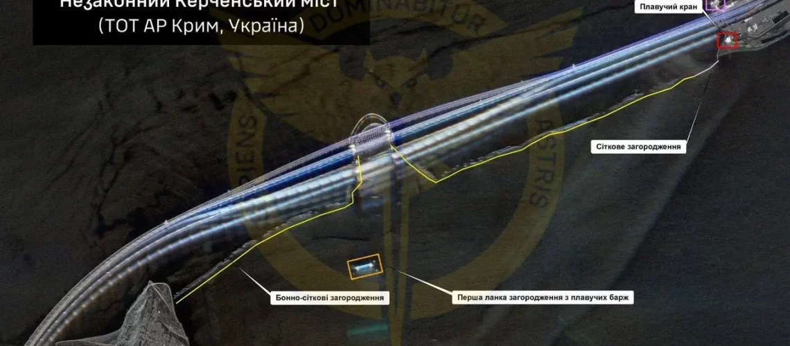
Photo: Satellite image of the Kerch Bridge, located in Crimea © Ukrainian military intelligence/Telegram, as cited in: https://kyivindependent.com/ukraines-crowdfunded-satellite-took-over-4-000-images-of-russian-facilities-military-intelligence-says/
This third and final part of our series dedicated to the new international spatial intelligence ecosystem examines the technological innovations that make the Japanese-Ukrainian partnership possible, particularly the commercial synthetic aperture radar (SAR) revolution, and analyzes the geopolitical implications of this transformation for the future of global spatial intelligence.
A Partnership Made Possible by Technological Leveling
Towards Low-Cost SAR Radar: A Commercial Revolution
The Japanese-Ukrainian partnership would not have been possible without a major technological revolution, namely the democratization of Synthetic Aperture Radar (SAR or RSO for « RADAR A SYNTHESE D’OUVERTURE » according to the French acronym).
Traditionally the monopoly of established space powers, this sophisticated technology is becoming accessible thanks to innovations from private actors like iQPS.
The Japanese company has achieved a remarkable technical feat by developing SAR satellites weighing only 100 kg and costing one-hundredth the price of conventional platforms. This revolution is based on a key innovation: a patented 3.6-meter deployable antenna that folds compactly at launch, then deploys in space using spring mechanisms (1).
This bowl-shaped antenna maintains curvature precision that minimizes signal distortion, enabling resolutions of 46 centimeters to be achieved (2).
Fighting the Fog of War, a Decisive Operational Advantage
Unlike traditional optical satellites that require clear skies and daylight, SAR satellites function in any weather condition and can operate at night. For Ukraine, a country at war facing harsh winters and difficult weather conditions, this capability naturally represents a considerable tactical advantage.
The radar can reveal thermal signatures of running engines, detect vehicles camouflaged under vegetation, map terrain changes caused by artillery, monitor troop movements even through smoke or debris, etc… (3).
These capabilities have already proven their worth: according to a Ukrainian report from 2024, nearly two-fifths of Finnish ICEYE SAR imagery accessible to Kiev since 2022 reportedly contributed to damage valued in billions of Euros within Russian forces (4).
The iQPS Constellation: Towards Real-Time Surveillance
Another comparative advantage at this stage, iQPS has deployed an ambitious constellation strategy. With five operational satellites as of April 2025, the company plans to reach 24 satellites by 2027, then 36 ultimately. Such a vision should enable observation of any terrestrial point with an average interval of ten minutes, revolutionizing near real-time surveillance (5).
Such a “swarm” approach radically transforms the economics of spatial intelligence. Where traditional satellites, expensive and complex, limited access to major powers, iQPS SAR micro-satellites continue to democratize this capability.
Medium-sized powers like Ukraine can now access cutting-edge technologies without depending exclusively on major historical space actors.
The Japanese Space Ecosystem Full Speed
The iQPS phenomenon is part of a Japanese space ecosystem in full transformation. The company Synspective is notably developing its StriX SAR constellation in partnership with the Japanese space agency JAXA (6).
Meanwhile, in May 2025, ICEYE and Japanese conglomerate IHI signed a cooperation agreement aimed at also developing a 24-satellite SAR constellation in Japan. Designed and operated locally, these satellites will respond to the country’s governmental, military, civil and commercial needs, while strengthening its strategic autonomy in Earth observation (7). This partnership between Finland and Japan, both economic “brothers in arms” of Ukraine, constitutes an evolution where the sky is definitely not the limit…
The government accompanies this dynamic with massive investments: more than 3.5 billion yen allocated to space in the 2025 defense budget, including a real-time surveillance satellite constellation and a new generation secure communications system.
Towards a New Order of Spatial Intelligence: When the Geopolitical Map is Being Redrawn in Space
Due to the multiplication of actors, diversification of technological sources, and weakening of traditional monopolies, the Japanese-Ukrainian partnership and the Finland-Japan-Ukraine cooperation triangle prefigure in a certain way the emergence of a new international spatial intelligence ecosystem.
This evolution responds to a logic of resilience against potential failures of numerous historical partners. It also reflects the adaptation of national security strategies to a world becoming truly multipolar where, for more and more international actors, classic alliances no longer seem capable of guaranteeing their national security.
Indeed, concerning Ukraine, the integration of Japanese SAR data via a two to three-month process represents more than a simple complementary capability surge: it is the assurance of critical redundancy in its intelligence sources.
For Japan, it is the affirmation of its status as a responsible space power, capable of influencing global conflicts through its technological innovations.
Such a new cooperation model, combining private innovation and state diplomacy, could well define the future of international spatial intelligence (8).
In a world where information proves to be a determining factor for conflict outcomes, technological leveling in the military space domain could well redraw the map of geopolitical balances on Earth as Above…
(By Murielle Delaporte)
Notes
(1) https://www.japan.go.jp/kizuna/2024/11/sar_satellites_for_disaster_monitoring.html
(2) See the following article on eoportal.org, ESA (European Space Agency) database: https://www.eoportal.org/satellite-missions/qps-sar#space-and-hardware-components
(3) According to the Nepalese information site, theasialive.com, “For the GUR [Main Intelligence Directorate of Ukraine], the advantages are immense. SAR images can:
– Detect troop and vehicle movements, even under camouflage nets.
– Identify terrain changes that indicate recent activity, such as trench digging or road construction.
– Monitor key logistical routes for fuel, ammunition, or reinforcement convoys.»
See: https://theasialive.com/satellite-warfare-japans-iqps-sar-satellites-set-to-strengthen-ukraines-intelligence-arsenal/2025/04/24/
(4) https://gur.gov.ua/en/content/prosto-kosmos-rezultaty-vykorystannia-narodnoho-suputnyka-iceye.html ; https://kyivindependent.com/ukraines-crowdfunded-satellite-took-over-4-000-images-of-russian-facilities-military-intelligence-says/
(5) https://i-qps.net/en/ ; https://spacenews.com/japans-iqps-lines-up-eight-sar-launches/
(6) https://global.jaxa.jp/press/2023/07/20230721-1_e.html ; https://www.thedefensenews.com/news-details/Japan-Steps-In-with-Satellite-Intelligence-Support-for-Ukraine-Amid-Uncertain-US-Backing/
(7) https://www.ihi.co.jp/en/all_news/2025/aeroengine_space_defense/1201450_13743.html ; https://www.iceye.com/newsroom/press-releases/iceye-and-ihi-start-cooperation-to-develop-sar-satellite-constellation-in-japan
(8) https://www.space.com/space-exploration/launches-spacecraft/rocket-lab-launch-private-japanese-radar-satellite-iqps-harvest-god-thrives
